
Page 77 - Industrial Plants
P. 77
Digitalization with mobile technology
and digital factory management
A case study and an Integrated survey with SLAM technology
Luigi Tornaghi, Sales manager and founding partner of 3Units
Enrico Trivini Bellini, Founding Partner at WESCAN and 3Units partner
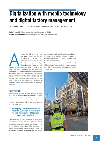
notable chemical plant in northern and the control points (specific points materialized on
Italy, which covers an area of the ground or on elevated surfaces) necessary to
approximately 160,000 m , improve and guarantee the required accuracy of the
2
commissioned us to laser scan the point cloud were measured.
plant with its consequent modelling. An instrument equipped with a double LIDAR sensor (2
A problem, common to very old x 300,000 points/second and 100 m range) equipped
The
systems, is that the documentation in hand did not with 4 full HD cameras (4x20 MPixel) was used for the
reflect the “as-is” conditions and represented an mobile survey.
inadequate basis for the management/maintenance of
the system which, as a consequence, can lead to
safety problems or reworks which delay projects and
increase costs. The scanning activities were performed
with “mobile SLAM” technology which guarantees a
reduction in time and costs compared to traditional
methods.
Our solution
We have developed a workflow that allows us to obtain
complete, accurate and reliable digitalisation of complex
systems in less time. In approximately two days a
complete survey was carried out with a mobile laser
scanner, integrated with traditional support topography
and geo referencing.
“Developing a workflow that allows
obtaining complete, accurate and
reliable digitalisation of complex
systems in less time
The introduction of mobile technology in an industrial
environment has allowed the digitalisation of all
structures, guaranteeing speed and accuracy. The
survey activities involved a team of four operators.
Initially, a topographic polygon was laid out to cover the
entire area, the apexes for georeferencing were drawn
IndustrIal Plants - May 2024
75