
Page 78 - Industrial Plants
P. 78
3Units
3Units is a sales and management company located in Canton Ticino (Switzerland), which
collaborates with primary companies for plant engineering and laser scanning activities;
operationally we are characterized by our extreme organizational flexibility, flexible working hours
that can be adapted to the needs of the project, a reduction in time and costs which is reflected in
the services and systems created.
Our staff is mainly composed of resources with more than twenty years of experience in the
commercial and marketing sector, plant engineers, professionals in the maintenance engineering
and software development fields. The sales department, in addition to being enriched by the
significant collaboration with Hexagon AB, world leader in the supply of software for infrastructure
engineering, is mainly involved in: plant engineering and 3D modelling, analysis engineering, laser
scanning activities and BIM design, project management and project control activities, software
and services for digital automation, digital twin, maintenance engineering and asset management
software and services, software solutions and services for productivity activities, logistics and port
services.
The Company is registered at the CC-TI Chamber of Commerce of the Canton Ticino, ATED ITC
Ticino and ANIMP National association of industrial plant engineering.
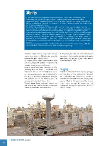
The limited weight, less than 9 kg, and the particular In the platform, the metric data of the point cloud are
ergonomics simplified the field work and allowed to completed in high resolution spherical photographic
always work in safety from the ground. images, giving full understanding and insight compared
By using the mobile scanner in parallel with a colour to a traditional point cloud.
point cloud, it is possible to obtain a virtual tour of high
resolution photographic spherical images.
Once the field activities were completed, the post-
processing phase was started for the creation of the Tagging
final dataset; the data from the mobile laser scanner All the items and assets of interest were then geotagged
were processed by entering the coordinates of the within the platform, linking additional information such
control points previously acquired for the verification as ID, parameters and characteristics as well as
and correction of the final trajectory and then attachments in different formats (text, images, audio,
reprocessed to obtain the final point cloud. video or HTML) to the coordinates of the surveyed
The entire dataset, filtered, cleaned and coloured, was object, which can then be synchronized with
then published and made accessible on a web-based maintenance management systems such as HXGN
platform for consultation and measurement. EAM for example.
IndustrIal Plants - May 2024
76